The link in the banner above is an excellent Google Map created for members by previous Secretary, David Farmer. This is your first port of call for where to fish, where to park, where the Association beats begin and end, what methods to use, and how to find the permit outlets.
The maps below are the basic ones issued with your permit together with important information about sensitive areas. These can be downloaded and printed. They show waters currently leased by the Association. All other water is considered to be private.

EAA Beats Overview Map August 2019. See the Maps below for details of leased and Private water.

The Area between the Pouch and the Estuary is designated a siteof special scientific interest. Take great care accessing the river in this area via the reed beds which are a haven for wild life. The EAA hold general consents which allow access and improvement on the river but any improvement work contemplated in this SSSI site must first be referred to the secretary.

Upper limit Ramornie Mains Bridge -Pitlessie - Springfield. (Note that Crawford Priory Beat on both banks is Private)
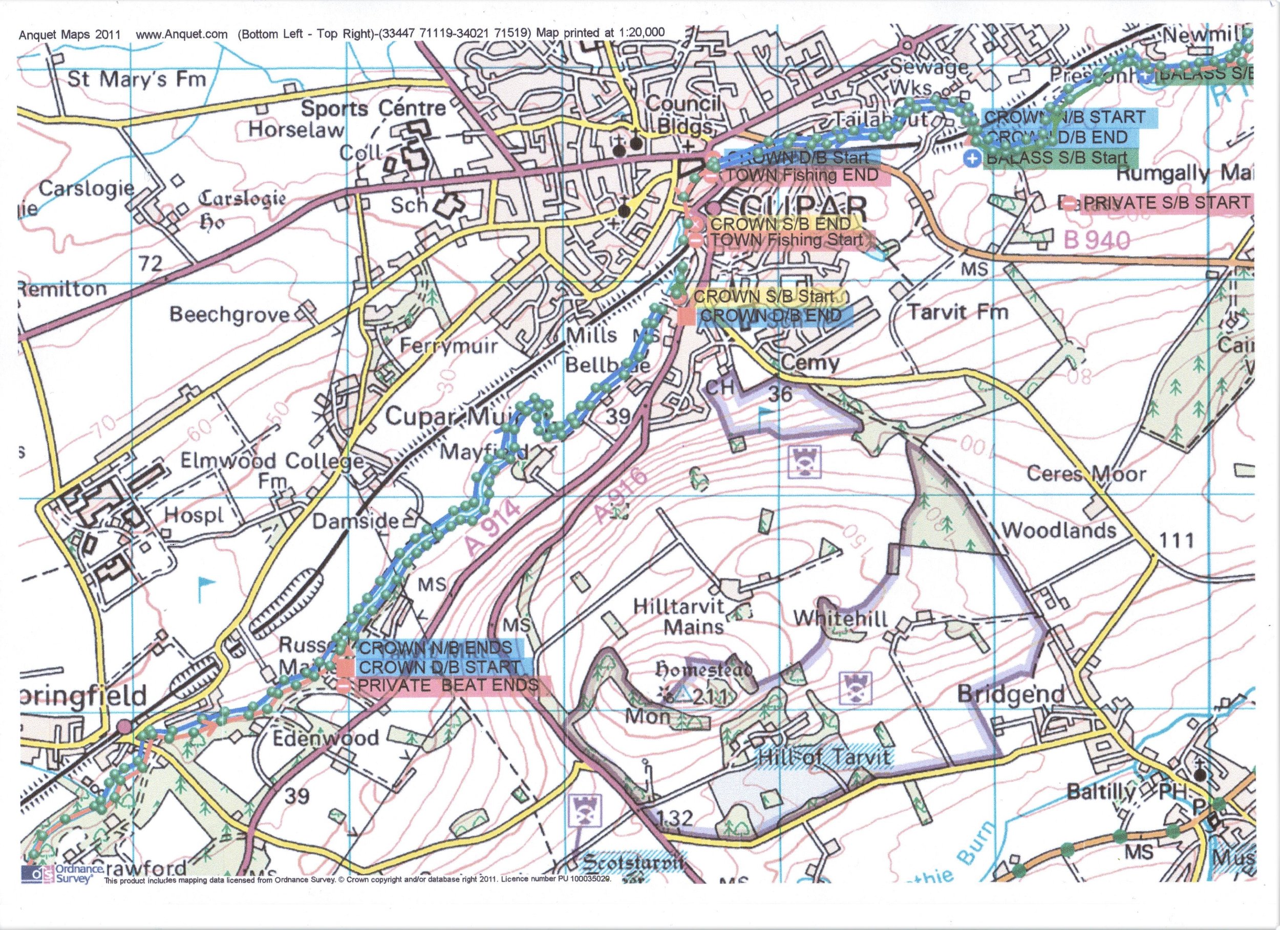
Springfield to Cupar . Note Edenwood Beat on South bank is Private.

Cupar to the Pouch. Crown North Bank to Pouch, Balass & Kemback. Note Rumgally Beat on the South Bank is Private.
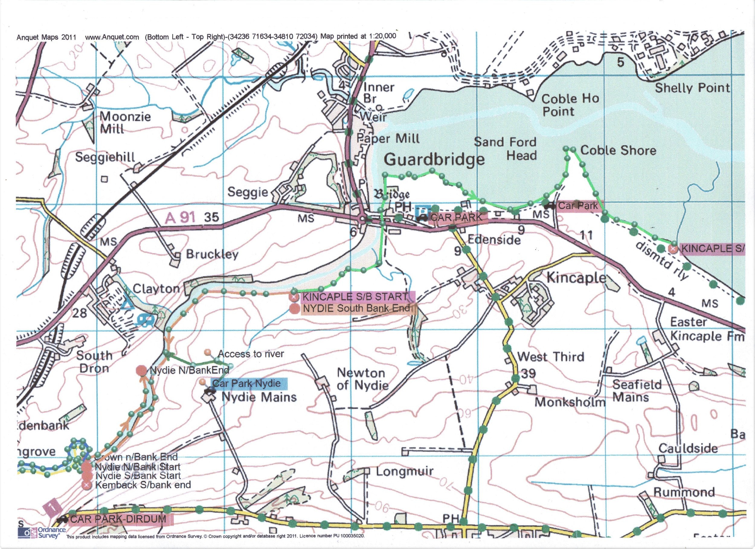
The Pouch Nydie & Kincaple & end of the fishing Permit water is at Easter Kincaple Burn. NOTE : This area is designated as a Local Nature Reserve & a site of special scientific interest (See link above as in addition to the rules of the river the rules of the LNR also apply)

Town or Private water marked GREEN. Crown Estates water leased by the Eden Angling Association marked in BLUE.
NO PARKING ON COMMON LAND BETWEEN THE COW BRIDGE & FISHERS LAUNDRY>

CERES BURN - EAST bank from the meeting of the river EDEN to the Waterfall (GREEN). Also the WEST bank from Sawmill Bridge to the Waterfall (ORANGE). All other sections are considered PRIVATE.
New Water - Shiels, Reedieleys and Barroway
From Season 2023 EAA took on some extra stretches of known fish-holding water on our Crown Estates lease in the upper reaches of the river (maps below). We initially did not publicise this as these are sensitive spawning waters. Our aim was to be able to monitor the water for spawning salmon and sea trout rather than encourage fishing. At the 2023 AGM, members felt there would be more monitoring of the area if it had more anglers keeping an eye on it. If fishing in this area, please remember that these are sensitive spawning habitats and report any concerns. It is not intended to spend time making these areas more accessible than they are now. In each case, fishing is North Bank only.

North Bank fishing at Shiels is part of the EAA Crown Estates lease

North Bank fishing on EAA Crown Estates lease downstream from Strathmiglo

A small stretch of North Bank fishing in the Barroway Burn south of Auchtermuchty on the EAA Crown Estates lease